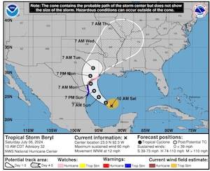
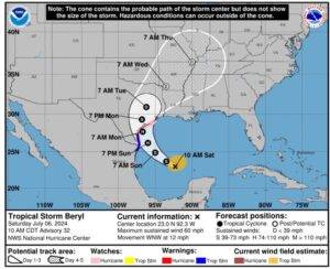
Beryl is sill a tropical storm and the track has not altered much. NWS forecasts it may make landfall as a Cat 1 storm (75pmh +). NWS models are showing that Chambers County may not even receive tropical storm winds (<39mph) due to the fact that the storm is relatively small in size. NWS maintains that the western counties of the region will receive the heaviest impact.
Sunday evening/night is still the expected timing of rainfall, wind, and surge.
Currently 5 to 10 inches of rain forecast. 3 to 5 feet of tidal surge possible. The areas that NWS predicts surge are those along the coast and also at the northern portion of Trinity Bay into the Trinity.
We will continue to keep you updated as there is still time for the storm to move and we will continue to monitor for any new developments for our area.
Facebook LinkedIn Pinterest Email Print By Rev. Carl A. Vickery, Calvary Tabernacle, Winnie The Importance of Attending Church As summer heats up and our world is filled with constant demands, attending ...
Facebook LinkedIn Pinterest Email Print By Madison Holifield, East Chambers FFA Reporter The 98th Annual Texas FFA State Convention was a week filled with achievement, leadership, and unforgettable experiences ...
Facebook LinkedIn Pinterest Email Print By Michael J. Lyons, D.O., Chief Medical Officer Coastal, Gateway Health Center July marks the observance of Group B Awareness Month, a crucial campaign aimed ...
Facebook LinkedIn Pinterest Email Print Flooding batters Hill Country once again A massive amount of rain once again engulfed the Hill Country, causing widespread flooding in several counties, including ...
Facebook LinkedIn Pinterest Email Print 1,247 people were killed in speed-related crashes in Texas last year AUSTIN – In Texas, getting there a few minutes faster isn’t worth a lifetime of consequences. Choosing ...
Facebook LinkedIn Pinterest Email Print Babin Bulletin | July 19, 2026 House Passes SAVE America Act Again Dear Gloria, This week, House Republicans took another important step ...