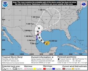
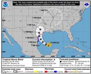
Beryl is sill a tropical storm and the track has not altered much. NWS forecasts it may make landfall as a Cat 1 storm (75pmh +). NWS models are showing that Chambers County may not even receive tropical storm winds (<39mph) due to the fact that the storm is relatively small in size. NWS maintains that the western counties of the region will receive the heaviest impact.
Sunday evening/night is still the expected timing of rainfall, wind, and surge.
Currently 5 to 10 inches of rain forecast. 3 to 5 feet of tidal surge possible. The areas that NWS predicts surge are those along the coast and also at the northern portion of Trinity Bay into the Trinity.
We will continue to keep you updated as there is still time for the storm to move and we will continue to monitor for any new developments for our area.
Facebook LinkedIn Pinterest Email Print New challenge to school funding system The Midland school district is suing Education Commissioner Mike Morath and other state leaders in another challenge to ...
Facebook LinkedIn Pinterest Email Print Babin Bulletin | July 26, 2026 Common Sense Vs. Communism Our nation is facing an epidemic. It’s one the world ...
Facebook LinkedIn Pinterest Email Print The East Chambers High School Lady Bucs took advantage of an outstanding opportunity to sharpen their skills during a recent softball camp hosted by the ...
Facebook LinkedIn Pinterest Email Print By Nick Canizales From Friday night dominance to coaching the next wave of talent, Tramain Thomas has built a legacy that still resonates across ...
Facebook LinkedIn Pinterest Email Print There were 54 subjects booked into the Chamber County Jail between July 19 and July 25. These subjects included: Sequoyah Denay Taylor, 04/05/2002, of ...