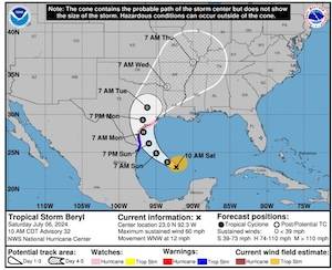
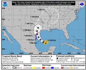
Beryl is sill a tropical storm and the track has not altered much. NWS forecasts it may make landfall as a Cat 1 storm (75pmh +). NWS models are showing that Chambers County may not even receive tropical storm winds (<39mph) due to the fact that the storm is relatively small in size. NWS maintains that the western counties of the region will receive the heaviest impact.
Sunday evening/night is still the expected timing of rainfall, wind, and surge.
Currently 5 to 10 inches of rain forecast. 3 to 5 feet of tidal surge possible. The areas that NWS predicts surge are those along the coast and also at the northern portion of Trinity Bay into the Trinity.
We will continue to keep you updated as there is still time for the storm to move and we will continue to monitor for any new developments for our area.
Facebook LinkedIn Pinterest Email Print From Barbers Hill ISD Facebook Barbers Hill High School proudly celebrates the outstanding accomplishments of its Business Professionals of America (BPA) students who competed ...
Facebook LinkedIn Pinterest Email Print On Thursday, March 19th, Mr. Florian, a graduate of the University of Texas, presented the documentary “Sam Houston: American Son, Texas Legend”. This documentary was ...
Facebook LinkedIn Pinterest Email Print By Rev. Andrew H. Simpson, Pastor of Mount Horeb MBC The rich young ruler asked The Lord Jesus the same question many desire to ...
Facebook LinkedIn Pinterest Email Print By Michael J. Lyons, D.O., Chief Medical Officer, Coastal Gateway Health Center As March’s National Kidney Month heads into its final weeks, communities across the ...
Facebook LinkedIn Pinterest Email Print Islamic schools admitted to voucher program after suit Four Islamic schools have been admitted to the Texas voucher program after a federal judge ordered ...
Facebook LinkedIn Pinterest Email Print Babin Bulletin | March 22, 2026 DHS Shutdown Drags On as Trump Deploys ICE to Support Airports It is incredibly disappointing ...